There's just something about covered bridges. There are few remaining in Illinois. Just southeast of Springfield in Glenarm is Sugar Creek bridge built in 1880.
Sugar Creek covered bridge, Sangamon County, Illinois
There's just something about covered bridges. There are few remaining in Illinois. Just southeast of Springfield in Glenarm is Sugar Creek bridge built in 1880.

Sugar Creek covered bridge, Sangamon County, Illinois
Our biggest snowfall last night has closed schools, courts, and offices for the first time in a few years. It seems appropriate to visit some snow scenes from Mt. Rainer National Park.
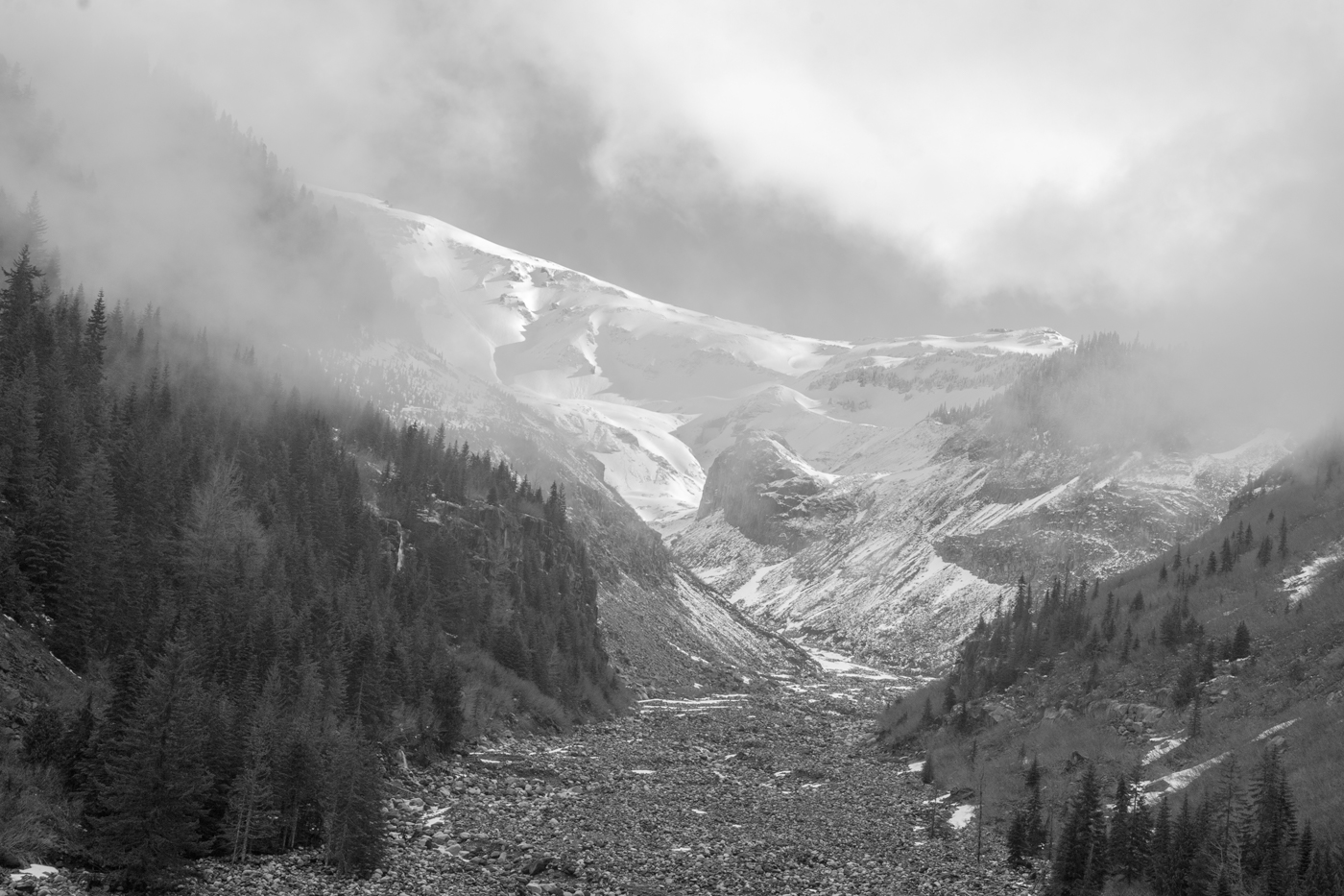
Nisqually River Valley, Mt. Rainer National Park
The glacier carved valley on the southern slope of Mt. Rainer leads up to the what remains of the glacier today.

Paradise, Mt. Rainer National Park, Washington
Paradise averages 54 feet of snow a year, and fog keeps the peak of Mt. Rainer hidden.

Ascending Mt. Rainer
Skiers undertaking an ascent of the mountain.
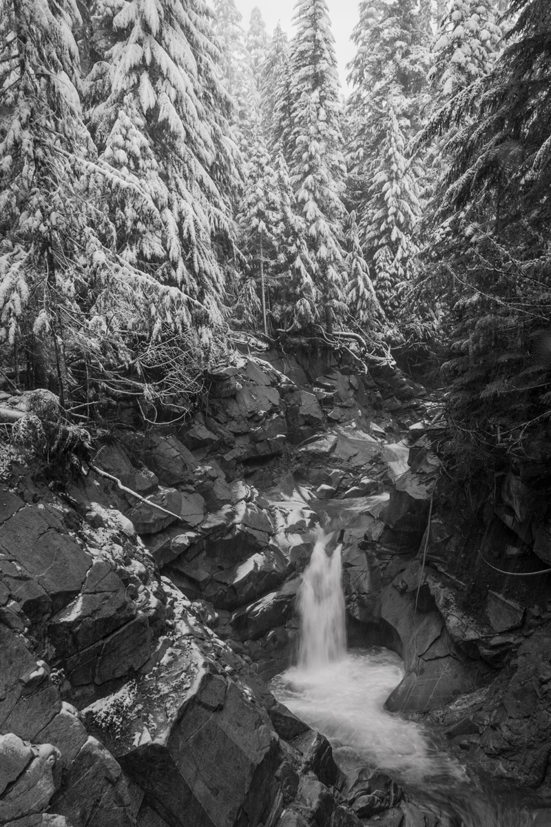
Christine Falls, Mt. Rainer
New snow at Christine Falls made getting to a view to photograph a bit challenging, but well worth the trek.
Merritt Island National Wildlife Refuge is on Cape Canaveral between the Indian River lagoon and the Atlantic Ocean. The Indian River is one of the most productive, diverse lagoons running along much of the east coast of Florida. This fellow is cast netting for some dinner at sunset.

Cast netting Indian River lagoon
East of the river is a complex system of wetlands and barrier islands called Cape Canaveral. The Kennedy Space Center and Merritt Island National Wildlife Refuge are home to mangroves and lots of alligators, manatees, bobcats,wintering birds, and assorted other critters.

Blue hour dusk, Merritt Island National Wildlife Refuge, Florida
Along the coast is Canaveral National Seashore. Jutting well out into the water, it was undoubtedly seen by Ponce de Leon. While long thought he first landed north near St. Augustine 500 years ago, it is now believed it was just south of here.
Canaveral National Seashore
I had the pleasure this week of attending the opening of a pop-up exhibit of Glenn Hansen's Time Well Spent photo exhibit at the McAninch Arts Center at College of DuPage. Glenn is former president of the College of DuPage Faculty Association and photography professor. The exhibition closes Saturday, and he has a gallery talk at 1 p.m. If you are in the area, I encourage you to see this wonderful display of 40 years of work.
I was particularly inspired by the portion of the collection he titled View from the Shoulder, of images of the Western U.S. from the roadside. It made me want to get on the road out west. He's got a few of those posted in the High Plains page on his website www.glennhansen.com. Even better, see the prints!
Here are some of my stops along the road.

ranchland, Highway 89, Wyoming

Government Creek Road, Billings County, North Dakota

Carrizozo, Route 54, New Mexico
If you see this place while driving on Route 54 in New Mexico, stop across the street for a Green Chili Burger . . . and a cold beer.

Church Rock, Route 191, Utah
My mother grew up on the Iron Range in northern Minnesota. She would tell stories of deep, long winters there. Unfortunately, I've never been there in deep winter, but winter lasts so long that I got a taste of it in early spring a few years ago. The lakes stay frozen a looonnngg time.
Bear Lake State Park, Minnesota

Bear Lake through the birches
Not far from the Iron Range is the dramatic North Shore of Lake Superior. An iconic view there is Split Rock Lighthouse.

Split Rock Lighthouse
A series of state parks line the coast. This is a view of Shovel Point in Tettegouche State Park. I learned a costly lesson here about securely balancing your tripod on uneven, rocky ground.

Shovel Point, Tettegouche State Park, Minnesota
The Firehole River in Yellowstone National Park must be one of the most aptly named bodies of water. It enters the Upper Geyser basin just behind Old Faithful through a heavy forest.

Geyser Hill trail across Firehole River
It loses tree cover as it enters the Upper Geyser basin.

Upper Geyser Basin, Yellowstone National Park
Super heated water from thermal features enter the river. The constant temperature is a home to a multitude of colorful thermophile (heat loving) bacteria. The River runs near iconic Old Faithful Lodge.

Old Faithful Lodge
Bison graze for meager food along the warm banks of the river. The river is only 21 miles long as it flows from the Continental Divide, into the Madison River which is one of the three main tributaries of the Missouri which joins the Mississippi as the longest river system in the contintent.

Bison along the Firehole River
I usually choose a nature scene for my Friday Foto posts. But most of my time is spent in the urban environment of downtown Chicago. So for the end of the year, I'll post some of my favorite shots when I had my camera downtown this year.

Chase Bank, Dearborn Street
First, a trip along Dearnborn Street. Look up near Madison and you get this view. Down the block is great local hat store.

Optimo Hats, Dearborn Street
Heading north, you get to the Chicago River.

Dearborn Street Bridge, Chicago Riverwalk
Then crossing the river on the Michigan Avenue bridge with the Tribune Tower and Wrigley Building.

Michigan Avenue bridge in the Windy City
It seems some of my favorites this year were of bridges on the river. Sunrise on LSD.
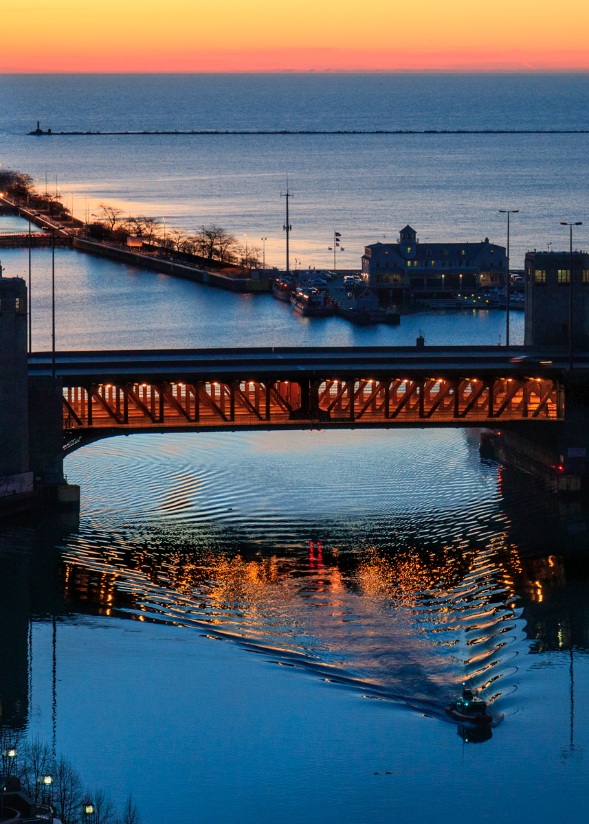
Lake Shore Drive bridge sunrise
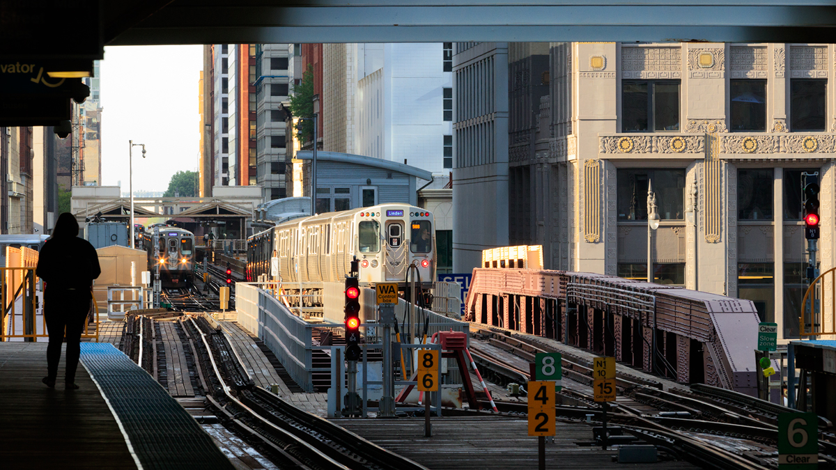
Merchandise Mart Elevated Train stop
OK, the last bridge shot is of the El going over the river.
Time for some cold weather looking out over Lake Michigan from Northerly Island.

Lighthouse and water crib Lake Michigan from Northerly Island
A final view back at the skyline on a cold, December morning.

December skyline
The press has been reporting stories of Snowy Owl incursion from their Arctic home into the upper Midwest this year. Ornithologists still don't seem to know with certainty why these incursions occur. The theory used to be that lemming and other rodent population in the north crashed sending the owls south to find food. The current theory is that a large lemming population in the Spring led to a lot of owl births and so the young move south into new territory because of the large numbers. In 2010 there was an incursion of Great Grey Owls and my son Dan and I traveled to Minnesota and were fortunate to find some.

Great Gray Owl, Aitken County, Minnesota
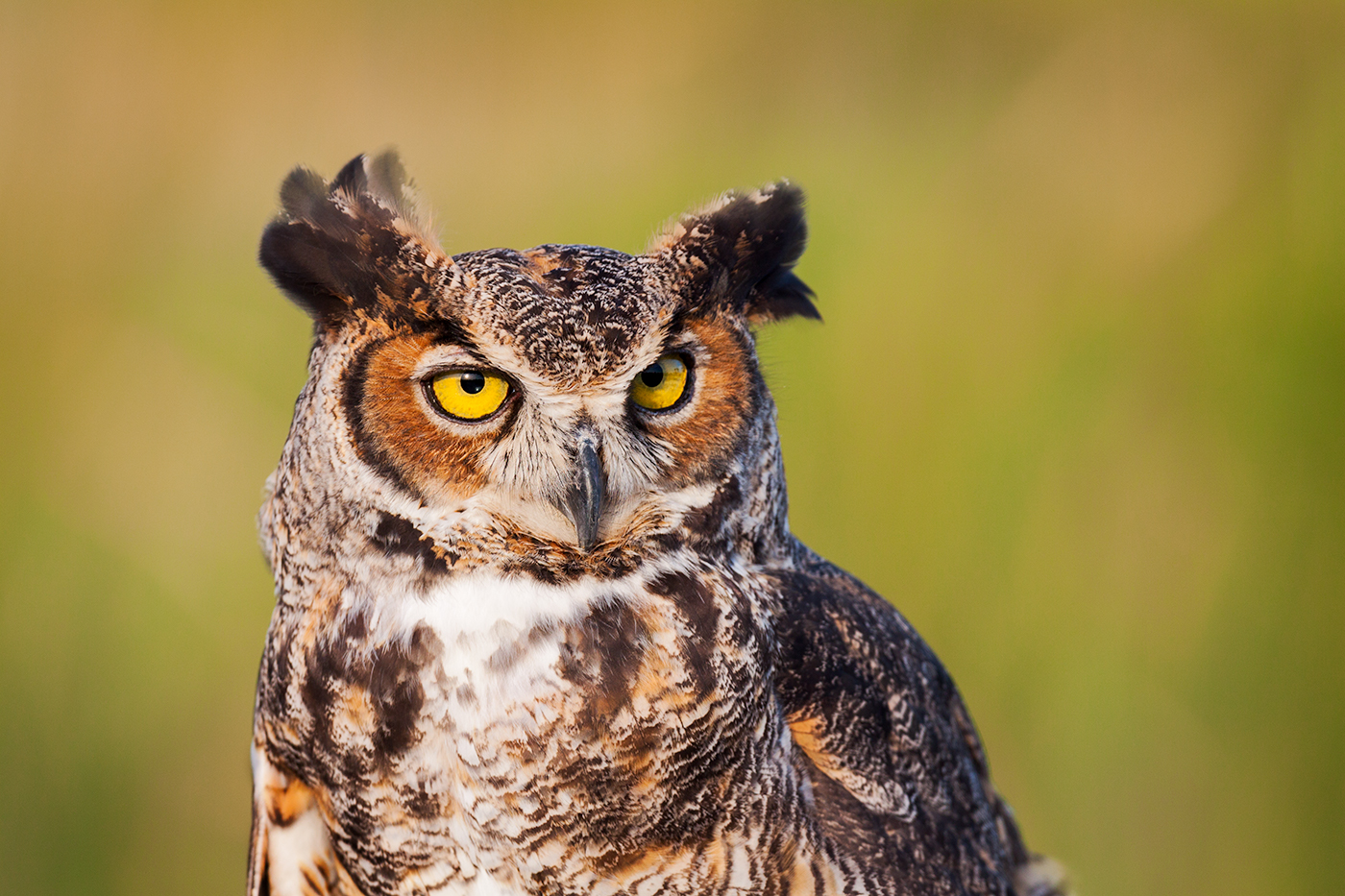
A few years ago, I read reports of a Great Horned Owl nest in St. Cloud, Florida when I was visiting and was fortunate to have one of the chicks raise its head above the feathers from leftover food its parents brought.

Great Horned Owl chick, St. Cloud, FL
One of my favorite encounters with an owl was finding a Burrowing Owl on a hike in Florida. Unfortunately, I can't find the images. Grrr. I did find this image of a captive Eastern Screech Owl that was being rescued in St. Augustine, FL.
Eastern Screech Owl
When Snowy Owls had an incursion a few years ago that went down to Florida, one found a good source of food among the rodents and other creatures at Montrose Harbor in Chicago. I was not locating it, when in the distance I saw a white bird flying. As I looked through my lens, it flew toward me, until it got so close I couldn't focus and it flew a few feet next to me. What a first encounter! I got some good flight shots and then this one when it landed nearby. If you find reports of Snowies in your area this year, I hope you can find one of these magnificent creatures.

Snowy Owl, Montrose Harbor, Chicago, IL
A small herd of bison spent the night on a small rise near Old Faithful geyser where the snow was melted because of the thermal feature underground. The constant mist from the geysers covered the bison in frost as they huddled together.
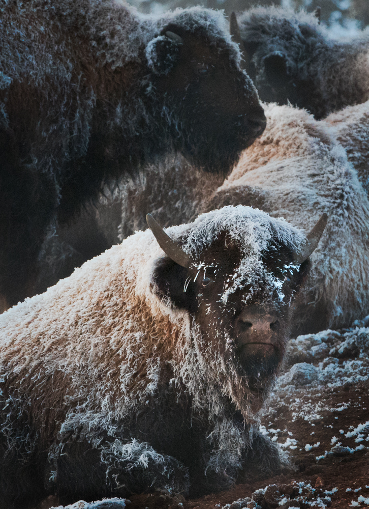
Frosty cow bison
The bison began to rise along with sun to move to new ground.

Frost-covered yearling
A path was soon created as the herd moved into the valley.

Bull and cows plow through the snow
Soon much of the herd were heading in the valley along the tree line.

Winter line of bison, Yellowstone National Park, Wyoming
One mother and her calf, who insisted on milk, remained behind as the sun got higher in the sky behind the mist of Old Faithful.

Sunrise, Old Faithful Geyser
The Antiquities Act became law in 1906 in significant part to protect ancient American archaeologic sites as well as vast natural areas such as Grand Canyon. The Act gives presidents power to designate and protect these national treasures as National Monuments. Navajo National Monument was created in 1909 by President Howard Taft to protect these remote ruins from further destruction by vandals and souvenir hunters.
The red rocks that make up the geography of this area reflect their color back up to the clouds.

Navajo National Monument, Arizona
Betatakin cliff dwelling and Keet Seel are two major protected sites in the monument. The surrounding protection also prohibits mineral exploration and extraction. President Trump's removal of similar protection from most of Bears Ears and Grand Escalante National Monuments this week allow mineral extraction such as fracking which results in increased seismic activity which will destroy nearby ruins.
The pinyon pine nuts were a significant part of the ancient culture that lived here. When we visited, the nuts were ripe. Just outside the park, many people were harvesting in the pinyon forests surrounding the area.

Pinyon pine
Unfortunately, our short visit did not allow us to reserve a ranger led hike in Betatakin as the people in this image were enjoying.

Betatakin alcove hike
Monument Valley in Navajo Nation on the Arizona-Utah border is iconic as any location in the Southwest U.S. From early Westerns to Forrest Gump to car commercials today, the buttes serve as classic backgrounds of the West. I'd never been to this remote area, but several years ago, I got a shot from a plane window.

Monument Valley at 30,000 feet
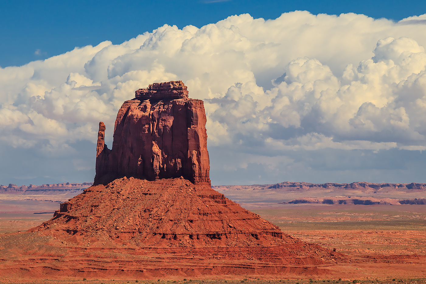
Sentinel Mesa in the top right is in Utah. Immediately below that in the right center, in Arizona, is West Mitten, Merrick Butte and East Mitten.

West Mitten Butte, Monument Valley Navajo Tribal Park
East Mitten Butte
The Tribal Park visitor center provides a terrace on John Wayne's Viewpoint of West Mitten, East Mitten and Merrick Butte. In the aerial shot above, the white visitor center building is in the upper center next to the large mesa. Two years ago, I ran into a man in a wheelchair in Chicago who said he was an extra in several John Wayne movies. He sure looked as though he could've been.

John Wayne's Point, Monument Valley
Unlike the red sandstone of the buttes, Algathla Peak is a volcanic plug--the eroded igneous rock that's left from an ancient volcano. It is easy to feel why it is sacred to the Navajos.

Algathla Peak, El Capitan, Navajo Nation, Arizona
Just north of Monument Valley is Bears Ears National Monument, protected by President Obama. For the first time ever, it is expected that on Monday a president will remove the protections of National Monument land reducing the size of Bears Ears Monument by 85%. This will place thousands of ancient archaeologic sites at risk, make native holy sites vulnerable and open the land to mineral exploitation. http://www.sltrib.com/news/environment/2017/11/30/report-trump-to-cut-crucial-landscapes-out-of-grand-staircase-and-bears-ears/
Capitol Reef National Park has remarkable sandstone features. Cathedral Valley road requires four wheel drive to get through the rough road, but we gave up before trying to cross a wash that was flowing from the previous night's rain. Here's a view of Temple of the Sun monolith on the left side.

Cathedral Valley Road view
Cottonwoods grow along the Fremont River that bisects the park and provide a nice foreground for the sandstone features.

Capitol Reef National Park, Utah
Mormons settled along the Fremont River in the 19th century and planted fruit groves and named the community Fruita. The Park Service maintains the groves and you can pick fruit to eat, and after a hike get some incredible fruit pies to eat and enjoy the view. This trail rises above Fruita and leads to a massive hanging canyon.
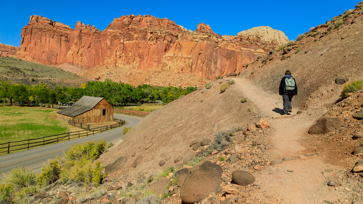
Cohab Canyon trail above Fruita
Autumn in the Wasatch mountains in Utah really surprised me for the lovely rural scenes and dramatic color. Since there wasn't much fall color in Illinois this year, I'm still living off this majestic color.

Aspen ridgeline
Plenty of ranchland and horses.

Autumn horses
Plenty of active and abandoned barns along the roadways.

Sunrise Utah Route 16
Northern Harriers and other raptors searched the ranchlands.

Northern Harrier
It is unfair to describe a hike in the Wyoming wild to be mundane, but a trail up a rise at Fossil Butte National Monument was lovely and peaceful, but not especially photographic. A ranger described some wildlife I might see, and I really wanted to photograph a badger. But no luck. The wind was fierce and darkness was coming on, so I needed to get back to the car.
Then I turned, and on the ridge of the butte were some bull elks silhouetted against the sky. Then I could see dozens, no hundreds, of elk in the shadows of the hills. As I got to the car, I was able to get this image of the sun setting.

Sunset, Fossil Butte National Monument, Wyoming
As it got dark, the elk were bugling and crying out and you could hear the bulls battling with antlers clanging together. It darkened and the sounds seemed to get louder as the stars got brighter.

Milky Way, Fossil Butte National Monument
Here is some audio from my camera. Not great recording, but it will give a sense of the night sounds of the elk. At about 12 and 15 seconds are the indistinct sounds of antlers coliding.
Capitol Reef National Park in south central Utah is a long, narrow park encompassing a 100 mile long wrinkle in the earth (a monocline). It is nearly impossible to cross -- why early European-American settlers called it a reef, like an uncrossable ocean barrier. The Fremont River trickles through and sustained the Fremont Culture beginning about 500 CE. They left petroglyphs on canyon walls.

Fremont culture petroglyphs
Some current residents keep watch along the wall.
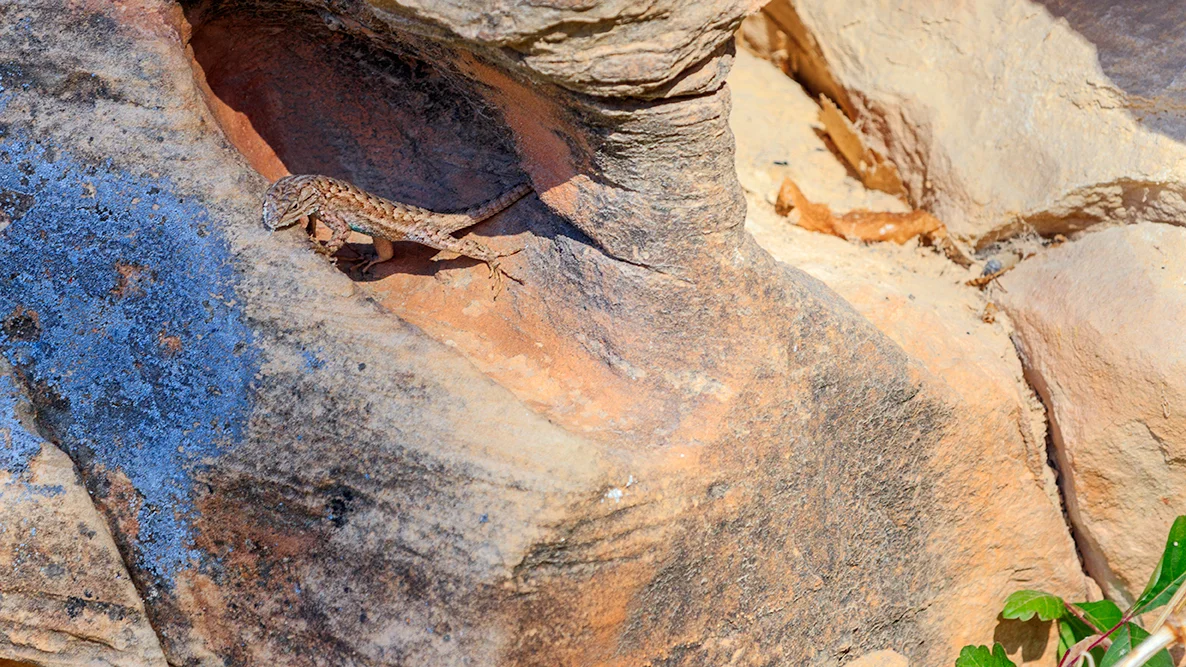
Sagebrush lizard
Utah Highway 24 is the only way across the Park today, but pioneers brought their wagons through Capitol gorge, a narrow path between steep canyon walls.

Capitol Gorge Trail
Capitol Gorge still has remnants of the early electric lines that were strung through this access, and pioneers and later travelers added their names in the walls next to ancient petroglyphs.
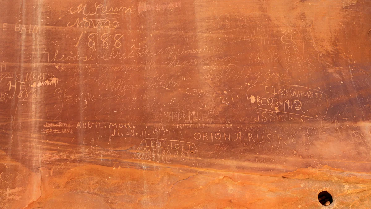
Pioneer Register
These markings, too, have their current protector.

Scorpion
We left the red rock walls of the Park at Panorama Point watching the sun set and the moon rise.

Panorama Point, Capitol Reef National Park, Utah
Bucolic: origin from the Greek boukolos, cowherd or herdsman.
Driving in the Wasatch Mountains outside Salt Lake City was a revelation. I never expected flaming autumn colors. Or open range. With cowboys and dogs herding sheep along the road, and then around a corner more cowboys with cattle in the middle of the road.
Heading back to Salt Lake City on the state highway, I saw a little dirt road beckoning, and a quick exit led to a scene I won't forget.

Autumn in the Wasatch Mountains
After soaking in the wide grandeur, it was time to capture some details.

Aspen

Twin firs

Utah Pastoral
And I was readying to leave, the cows circled for a pleasant composition. A very fortunate detour.

Wasatch bucolic
This park holds the world's largest concentration of natural arches. Landscape Arch is the longest. A football field could fit underneath it. The day started overcast, rainy and sleeting.

Landscape Arch
There were lots of Ravens in Utah, and I really wanted a picture. So this fellow accommodated me and came by for a visit while we sitting and enjoying the view of Delicate Arch. This is the arch depicted on Utah license plates. Blue sky was starting to peek through.

Raven and Delicate Arch
My favorite, though, was Double Arch.

Double Arch
Three arches are in this sunset scene of the Windows section of the park under the snowy LaSal mountains. It's easy to see the one arch on the left. The two in the center are a bit of a challenge to spot.

Windows, Arches National Park, Utah
Canyonlands National Park in southern Utah is one of the most remote locations in the U.S.. However, I had to wait for a bus load of Chinese tourists to finish their group photo before getting an image of on of its iconic locations: Mesa Arch.

Mesa Arch at sunrise
Then it was time to peer over the edge.

Mesa Arch, Canyonlands National Park, Utah
The northern part of the Park, between the Colorado and Green Rivers is called Island in the Sky and provides vast vistas.

Grand Point, Canyonlands
A few morning clouds lingered in the canyon of the Green River.

Canyonlands National Park, Utah
Saguaro National Park is in the Sonora Desert just north of the Arizona border with Mexico. I drove into the western unit of the park near sunset. It is an alien world.
Here's a prickypear cactus with its arms open wide to welcome you. You may not wish to return the embrace.

Pricklypear
If that didn't get your attention, continuing the welcome is Jumping Cholla.

backlit cholla
Time for a close encounter with Barrel cactus. You can see one behind the prickly pear above.

Barrel cactus
After sunset, rich colors fill the sky and Tucson mountains.

Dusk in Tucson Mountain District, Saguaro National Park, Arizona
The ancient rulers of this land, the Saguaro cactus, great the night and the rising moon.

Giant Saguaro and tiny moon
The trees are changing here and some promising color seems to be on the way. Here's hoping some Midwest scenes such as these this year.

Bear Head Lake, MN

Devils Lake, WI

Eagle Cliff, Starved Rock State Park, IL

Iowa Farm